K. Ikeuchi, T. Oguchi, M. Kuwahara, S. Ono, T. Oishi, S. Kamijo, A. Mitsuyasu, K. Koide, R. Horiguchi, M. Iijima, H. Hanabusa, M. Yoshimura, Y. Kameda, K. Mori, A. Tanaka, T. Matsunuma, H. Goto, M. Hasegawa, M. Suda, S. Sasaki, K. Kishi, S. Yorozu, H. Ichiawa, D. Oshima, Y. Tamura: "8% Reduction of CO2 Emission by Raising Awareness of Citizens: Development and Evaluation of Regional Transport Information System for Promoting Eco-Friendly Travel Behavior", ITS World Congress, 2015.10
 A. Kumar, Y. Sato, T. Oishi and K. Ikeuchi, "Identifying Reflected GPS Signals and Improving Position Estimation Using 3D Map Simultaneously Built with Laser Range Scanner," 13th ITS Asia-Pacific Forum, Auckland, New Zealand, April 2014.
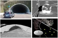 L. Xue, S. Ono, A. Banno, T. Oishi, Y. Sato, K. Ikeuchi, "Global 3D Modeling and its Evaluation for Large-Scale Highway Tunnel using Laser Range Sensor," In Proc. 19th ITS World Congress Vienna, Oct. 2012, Austria. (Best Paper Award)
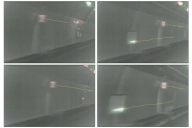 Z. Wang, M. Kagesawa, S. Ono, A. Banno, T. Oishi, K. Ikeuchi, "Detection of Emergency Telephone Indicators in a Tunnel Environment," International Journal of Intelligent Transportation Systems Research, Jan. 2014.
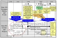 K. Koide, T. Oishi and K. Ikeuchi, "Historical Analysis of the ITS Progress of Japan," International Journal of Intelligent Transportation Systems Research, pp. 1-10, 2015.